Montgomery County, initially part of Wilson County, was established in 1867 and organized in 1869, despite much of its land still being under Native American jurisdiction. Its borders were defined by the legislature, although inaccuracies in land surveys persist. The county’s diverse geography includes the Verdigris River and various creeks, while its rich agricultural potential is complemented by natural gas and oil deposits. The historical narrative involves complex interactions between settlers and Native Americans, particularly regarding land treaties that shaped ownership. Despite early land disputes, settlers eventually secured clear title through government transactions, resulting in a stable landholding environment.
During the earlier history of Kansas the territory which now constitutes Montgomery county formed a part of Wilson county. The latter county was created by act of the territorial legislature in 1855, but it was not organized until September 1864, at which time it extended from Woodson county to the south line of the state. Montgomery county was created by act of the legislature in 1867, a little more than half of the southern part of Wilson county being taken for the purpose. By the act of the legislature which created the county, its boundaries were fixed as follows:
“Commencing at the southeast corner of Wilson county; thence south with the west line of Labette county to the thirty-seventh parallel of north latitude; thence west with said parallel twenty-four miles; thence north to the southwest corner of Wilson county; thence east with the south line of Wilson county to the place of beginning.”
This description depended entirely on the bounding of Wilson county, and, in 1870 the statute was changed to read as follows:
“Commencing at the southeast corner of Wilson county; thence south to the south line of the state of Kansas; thence west along the south line of Kansas twenty-four miles; thence north to the sixth standard parallel; thence east along the said sixth standard parallel to the place of beginning.”
This description seems to have meant exactly the same thing as the other, and yet neither of them is accurate, as the width of the county east and west, owing to the botchwork made in fitting together the surveys of the ceded lands and Diminished Reserve, is considerably more than half a mile above the twenty-four mentioned.
While all of the county except the three mile strip of ceded lands on the east side was still Indian land, and there was no treaty even pending
for their cession to the United States, saving the Sturgis abomination, which was never ratified, the county was organized by proclamation of Governor James M. Harvey, on June 3d, 1869. It was claimed that at this time the county had the requisite population of 600, and whether this was true or not, the progress of events soon made it an accurate statement. Verdigris City was designated as the temporary county seat, and a board of county commissioners was appointed. For further details as to the early history of the county and the story of the struggle which resulted in the selection of Independence as the county seat, the reader is referred to the chapter on the political history of the county.
Location of Montgomery County
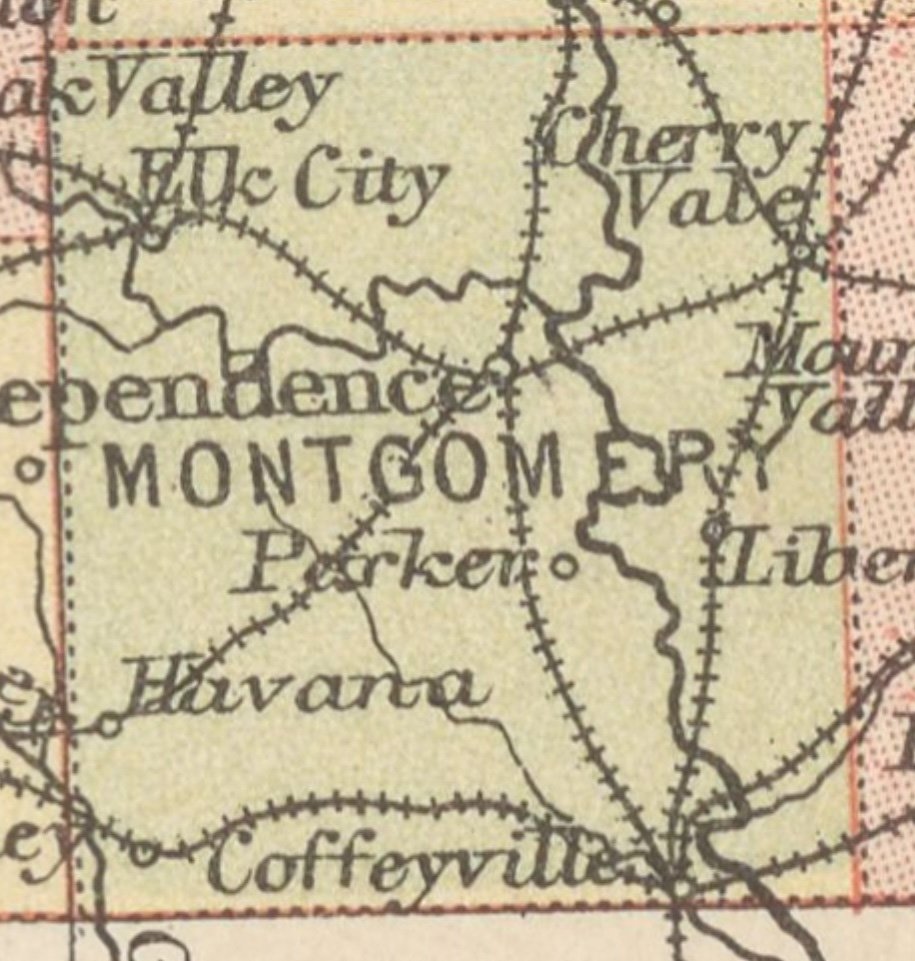
Montgomery county now ranks as the seventh Kansas county in population and, as shown by the United States census of 1900, forms a part of the largest contiguous area west of the Mississippi river, having a population in excess of forty-five to the square mile. It is between twenty-four and twenty-five miles in width east and west, and between twenty-seven and twenty-eight miles in length north and south. It is the third county west from the Missouri line, on the southern tier, and adjoins the Indian Territory on the south. Labette county forms its entire eastern boundary and Wilson its northern, while on the west it adjoins Chautauqua and a portion of Elk. Neosho county corners with it on the northeast.
Its physical features and soil are extremely varied. The Verdigris is the principal river, entering its northern boundary and meandering across to its southern. The Elk enters the west line of the county and forms another winding valley, emptying into the Verdigris about four miles northeast of the center of the county. The Caney cuts across the southwest corner of the county. Besides these rivers there are dozens of creeks and runs with much fine alluvial land adjoining them, in addition to the bottom lands of the rivers. Between the streams there are here and there rock-capped mounds and much high, thin, stony land, fit for little but pasture. Use is, however, now being found for the limestone that caps some of the mounds and outcrops along the streams in the manufacture of cement, while the shale that is abundant in the hills is extensively employed in the manufacture of vitrified brick. Taking her agricultural resources in connection with the abundant deposits of natural gas and petroleum oil found in the earth hundreds of feet below the surface, and remembering that Montgomery is the only county on the south line of the state that lies wholly within the gas and oil belt, we are certainly justified in saying that nature has done more for her than for any other equal area in the state.
The section of which this county of such boundless resources and possibilities forms a part, was first a portion of the French domain in America, having been taken possession of by the Canadians, who drifted down the Mississippi to the gulf in 1682. Eighty years later it was ceded to Spain, by whom it was retained until 1800, when it was retroceded to France. In common with the entire area of Kansas, except a small fraction in the southwest corner, it formed a part of the Louisiana purchase made by Jefferson in 1803, and has ever since been American territory, though little was known about it during the first half of the 18th century. The first legislation in regard to this section appears to have been enacted in 1831, when all the territory west of the Mississippi and Arkansas was declared “Indian country,” with the laws of the United States in force; and the country of the Osages was attached to Arkansas territory. In 1854 the territory of Kansas was organized and, in 1861, the territory became a state.
The country from which the present county was to be made still remained Indian territory, however. The Osage Indians were first found on the Missouri river, and, later, were forced down to the Arkansas. In 1808 they ceded their lands in Missouri and Arkansas to the United States government and went west. In 1825 they relinquished their lands in Kansas, except a strip fifty miles wide along the south line of the state, beginning twenty-five miles west of the Missouri line, near the present eastern boundary of Labette county, and reaching west to an indefinite line extended from the head waters of the Kansas river, southerly, through the Rock Saline. This was the Osage reservation, which comprised the largest body of good land in Kansas, remaining unsettled when the civil war closed in 1865.
Land Titles
The white men wanted these lands and were bound to get them soon in any event, but the return of the soldiers of the Union to civil life in 1865 no doubt hastened the movement to send the Indians westward again and make homes and farms out of these fertile Southern Kansas valleys to which they held title. At Canville trading post in Neosho county on September 29th, 1865, a treaty was negotiated which became operative January 21st, 1867, by whose terms the Osages sold a thirty-mile strip off from the east side of their lands for $300,000. This strip embraced the counties of Neosho and Labette, and a fraction about three miles wide along the east sides of Wilson and Montgomery counties. The contest between the settlers and the Missouri, Kansas & Texas and the Leavenworth, Lawrence & Galveston railroad companies for the title to these lands forms one of the most interesting chapters in the history of Labette county. This contest also involved the three-mile strip on the east side of Montgomery county and interested a considerable percentage of its population. It was finally decided in favor of the United States, under whom a portion of the settlers claimed title, leaving those who had bought their lands from the railroad companies to seek to perfect their titles anew.
These ceded lands were eventually entered under the pre-emption laws and paid for to the credit of the Osage fund in the government treasury.
The same treaty which cut off these Osage lands on the east also sliced off a twenty-mile strip on the north, leaving the “Diminished Reserve” but thirty miles in width, and as the territory narrowed the eagerness to possess it became greater. The corporations had an eye upon it, as well as the settlers, and on May 27th, 1868, a little more than a year before the rush of immigrants began to fill the county, there was negotiated on Drum Creek a treaty which for downright infamy outranks any other transaction in the history of the opening of the west to settlement and civilization. This treaty was known as the “Sturgis Treaty,” and is liberally treated under the head of “Drum Creek Treaty” in this volume.
Owing to a discrepancy between the southern boundary line of the state of Kansas and the south line of the Osage Diminished Reserve, there was a strip of land along the south line of Montgomery county, varying between two and three miles in width, which was claimed by the Cherokee Indians, and which was eventually sold for their benefit several years later. Actual settlers were given a preference in the purchase of these lands, but those which remained were disposed of in any desired quantity, and at a price somewhat higher than the settlers were asked to pay.
Land titles in the county were thus of four different kinds. The landholder may find his chain running back to a government patent originating in a purchase from the Cherokees or the Osages, and if the latter, it may be either of “Ceded” or “Diminished Reserve” lands. Or he may hold by virtue of a purchase from the state school fund commissioners. It was fortunate for the settlers, though, that for all except a small fraction of the area of the county, the contest between the corporations and the people was fought out before the lands were entered. They were thus freed from the long period of strife, the expense and the uncertainty which were the fate of their neighbors in Labette county and on the “Ceded” strip. The titles which they obtained when they paid the purchase price to the government and received their final receipts from the land office officials, have never been called in question, and the courts have been resorted to only to settle individual and isolated cases of rival claims to proprietorship.
The original government surveys of the lands in the county, however, were made in a very careless manner, the section and quarter section corners often being many rods from where they should have been, and the surveys of the “Ceded” and “Diminished” lands were so loosely connected that in many cases there are quarter sections on the line between that have as much as forty acres more than the government deeds call for.
Source
Duncan, L. Wallace. History of Montgomery County, Kansas: By Its Own People. Illustrated. Containing Sketches of Our Pioneers — Revealing their Trials and Hardships in Planting Civilization in this County — Biographies of their Worthy Successors, and Containing Other Information of a Character Valuable as Reference to the Citizens of the County; Iola, Kansas : L. Wallace Duncan, 1903.
Discover more from Kansas Genealogy
Subscribe to get the latest posts sent to your email.